Author: Janet

Did you #FindYourPark?

As I’ve been on this journey, I find myself repeating the same task over and over… I’m headed somewhere, I filter a list or open a book to find out what units are in that state and then I map them out and determine if any are close by. After what felt like the thousandth time, I created a tool that would simplify this process. In honor of the National Park Service’s #FindYourPark social media tag and since it was at the heart of this tool’s purpose, I decided to incorporate the tag into the name.

findyourpark

To interact with the site, please go here: https://www.tangible-america.com/NPS-FindYourPark.html

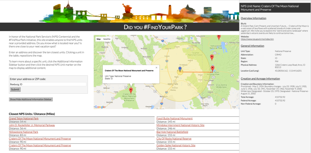
This site allows a reader to enter a location and it will highlight the ten closest NPS units. Additionally, it provides range circles to highlight what else might be within 5 or 50 miles. I chose these specific distances to give a reader the sense of what is “next door” and what is within an hour of the entered location. The last component of the site is a basic information source and pointer to NPS resources for more details. With or without entering an address, a reader is able to open an information panel and select any unit to learn more. The information panel includes, but not limited to: a brief blurb about the unit, the NPS unit’s website, the physical address of unit, and creation information. All information came directly from NPS sources.

In future phases of this tool, I’d like to add NPS affiliated areas as well as nearby transportation options (e.g., airports and train stations) to help with trip planning.

Now the question is, Did you #FindYourPark?

Next stop: Unit count and acreage overview

Now that I learned how the units within the National Park Service (NPS) are created and their high-level distinguishing characteristics, it is time to dig into the data. This brought an entirely new set of questions. How many units are there? What is the breakout by region? Does a specific region have more of one type of unit than another? What does the acreage profile look like for the NPS?

In order to explore these descriptive qualities, I created a Tableau visualization. The visualization allows the reader to explore and filter by a Grouped Unit Type (e.g., Some units such as National Battlefield, National Battlefield Park, and National Military Park are grouped under one unit) or by a Region. The regional breakout is by NPS Office regions. Using the color scheme of the visualization, the below map provides an illustration of the regional breakout.

US Map colored by NPS region


To play with a full size version of the visualization, go here.

 
An interesting discovery from this visualization was that the Intermountain range had more than two times the number of National Monuments than National Parks, even though we think of the region predominately for its National Parks. Another interesting discovery was that the Northeast had the most National Historical Parks and National Historic Sites, but the Northeast does not contain the most National Monuments or National Memorials. I believe this occurs because a significant amount of our National history is in close proximity within this region, which aligns to a grouping within the NPS system. For instance, most of the sights in Boston are all categorized under one unit, a National Historical Park. What did you discover?

Where to begin…

Before digging into all the National Park Service (NPS) data, my first goal was to understand the organization. I wanted to learn how something becomes part of the NPS (aka a Unit) and what the different designations signify. This provided me a way of understanding what I may learn or experience at each site.

Once a location is identified as a potential unit, the below flowchart outlines the general path it takes on its journey through our legislative and executive branches. Most NPS units are established via Congress, with National Monuments also able to be proclaimed independently by the President of the United States.

How are units added to the National Park Service?


How are units added to the NPS?

Source: Congressional Research Service: https://www.fas.org/sgp/crs/misc/RS20158.pdf


How are the National Park Service units organized and what are their characteristics?

From this I began reading about the different units within the NPS and one of my first questions was “What do all the unit designations mean? What are the differences between them?”  The first thing to understand is the required criteria for any unit of the NPS. The unit must be of national importance/significance and possess all the following standards:

  • Is an outstanding example of a particular type of resource
  • Possesses exceptional value or quality in illustrating or interpreting the natural or cultural themes of our Nation’s heritage
  • Offers superlative opportunities for recreation for public use and enjoyment, or for scientific study.
  • Retains a high degree of integrity as a true, accurate, and relatively unspoiled example of the resource

There are many similarities between the unit designations. This chart illustrates the significant differences.

Breakout of NPS unit classifications
To see a full size version of the image click here.

In addition to the units captured in the image, there are two more units used by NPS:

  • National Parkway: A motor roadway that parallels parkland. It is seen as a scenic drive along a protected corridor. A parkway often connects multiple sites.
  • Other Designation: In some instances, a given location has a unique title or combination of titles.

The NPS partners with other organizations and government levels (e.g., state/local) to help with the “Affiliated areas”. These areas are not part of the NPS but help preserve other significant resources or history. Finally, during the life of a NPS location, the designations will shift based on restructuring, additional land/property inclusion, or park needs.

Source: NPS – Criteria for Parklands Brochure: http://parkplanning.nps.gov/files/Criteria%20for%20New%20Parklands.pdf
Source: Congressional Research Service: https://www.fas.org/sgp/crs/misc/R41816.pdf
Source: Wikipedia – NPS: https://en.wikipedia.org/wiki/National_Park_Service


Welcome to Tangible America!

Hello, I’m Janet. I’m going to be your tour guide on this adventure. You’ve arrived at the start of a new project. Tangible America is a personal project that combines by love of data, photography, adventure, learning, and travelling. I consider myself an explorer on all fronts. I like pushing my limits and what I experience. It ensures that I’m evaluating my worldview and testing my beliefs. In the same weekend, you can often find me at a museum, a sporting or concert event, and taking a hike in the woods. For me, this variety is the spice of life.

While considering my next adventure, I began reading about the National Park Service and quickly realized that there were a number of places (even in my hometown) that I had never heard of and even more that I hadn’t ventured to. How did I not know about ones in my hometown??? I decided right then and there that this needed to be fixed.

This project will focus my journey on sites managed by the National Park Service (there are over 400 of them) but include other interesting finds along the way. My goal is to find and present an interesting story about each. It may be a story about the design of a monument, the wildlife endangered in a park, a personal story related to a memorial, or highlighting a new tidbit I learned during my journey there. Some locations will be more data driven, while others will be more experience driven. Each location will be presented with a visualization and photography. Basic information about the location and a link to additional resources will be included to continue the learning.

To see the quote by Edward Bearss (National Park Service Chief Historian Emeritus) that inspired the site’s name, check out the About page!

Have your water and your map? Maybe some snacks? You’re ready so let’s learn, let’s explore, and let’s celebrate the National Park Service’s Centennial!

© 2024 Tangible America

Theme by Anders NorenUp ↑